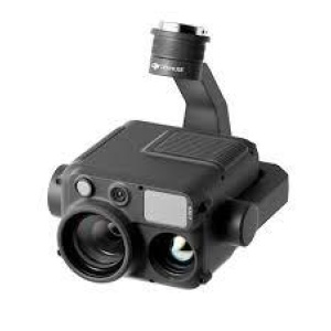
Description: High-Precision Aerial LiDAR System Zenmuse L2
Zenmuse L2 integrates frame LiDAR, a self-developed high-accuracy IMU system, and a 4/3 CMOS RGB mapping camera, providing DJI flight platforms with more precise, efficient, and reliable geospatial data acquisition. When used with DJI Terra, it delivers a turnkey solution for 3D data collection and high-accuracy post-processing.
Vendor Homepage: enterprise.dji.com/zenmuse-l2
Drone product line: Enterprise
Model name: Zenmuse L2
Drone accessory type: Other
Operating temperature range: -20° to 50° C
Dimensions: 155×128×176 mm
Units per Shipping Box: 1
Shipping Box Depth: 34.5
Shipping Box Height: 30
Shipping Box Weight: 3.27
Shipping Box Width: 24.5
Unit Calculated Volume: 0.02536
Product Net Weight: 0.905
Unit Calculated Weight: 3.27
CnCode: 85258900
Unit Box Width: 0.245
Unit Box Length: 0.345
Unit Box Height: 0.3
Category Code: DRA